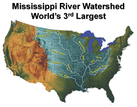
The Mississippi River Watershed is the world's third largest. It is the drainage basin for 41% of the continental United States.
ALEXANDRIA, VA—September 14, 2011. USACE hosted the U.S. Army Corps of Engineers (USACE) – U.S. Geological Survey (USGS) Quarterly Headquarters Meeting at IWR on August 24, 2011. Representatives from the National Oceanic and Atmospheric Administration (NOAA) attended in addition to USACE and USGS. The agenda had an emphasis on each agency's flood activities during and after the Mississippi River and Missouri River floods.
Scott Whitney, Mississippi Valley Division, presented information on Operation Watershed - Responding to the Historic Mississippi River Flood of 2011. Brigadier General DeLuca, Commander North Atlantic Division, presented on real-time streamgaging in the Susquehanna River Basin. In addition, Bob Holmes, USGS, discussed the USGS Response and Activities in the Mississippi and Red/Souris River Basins.
Another key discussion topic was Climate Change activities, including updates on the Water Sector Component of the U.S. National Climate Assessment, Council on Environmental Quality's National Action Plan for Managing Freshwater Resources in a Changing Climate, and the National Ocean Council Strategic Action Plan. IWR’s Rolf Olsen and Charles Chesnutt participated in presentations at the meeting.
Learn More