The primary objective in the Marais des Cygnes—Osage was to create an interstate working group to avoid interstate conflicts over water during drought. The river is officially designated as the Marais des Cygnes from its source in east-central Kansas to its confluence with the Little Osage River near Schell City, Missouri, where it becomes the Osage River and flows in an easterly direction into the Missouri River downstream of Jefferson City, Missouri. The basin is about 250 miles long, as much as 100 miles wide, with a drainage area of 15,300 square miles. A little less than a third of that area is in Kansas.
The Corps has six reservoirs in the basin: Melvern, Pomona and Hillsdale in Kansas; and Stockton, Pomme de Terre and Harry S. Truman in Missouri. Union Electric’s Lake of the Ozarks is located behind Bagnell dam, just downstream from Harry S. Truman. Union Electric uses Lake of the Ozarks for hydropower and recreation. Occasionally, in the winter months, Lake of the Ozarks supplements cooling water to a fossil fuel plant located on the Missouri River.
Kansas is an appropriation state with proactive water supply planning, which includes updating of a yearly water plan and partnership with the U.S. Army Corps of Engineers for pursuing water storage in several Corps reservoirs. Missouri is a riparian state in which local management has historically been favored over state direction. Funding for Missouri’s state water program was threatened during the DPS because of overall state budget pressures.
The potential problems in a drought situation are major impacts on power production and the recreation industry. For example, a major recreation and hydropower issue revolves around the operation of a private reservoir, Lake of the Ozarks, the most downstream reservoir in the basin. Created by Union Electric, the lake could be drawn down during a severe drought to provide electrical power to a region that includes St. Louis, Missouri. Most people in the region, however, know Lake of the Ozarks as a recreational lake and an attraction that induces tourists to spend as much as $5 million per week in the region.
During a sustained, severe drought, there are potential negative impacts to municipal and industrial users in Kansas and Missouri. Municipal users in Kansas include the cities of Ottawa, Osawatomie, Paola, and Ft. Scott. Municipal users in Missouri include the cities of Clinton, Springfield, Nevada, Stockton, and various Lake of the Ozarks communities. Kansas City Power and Light in Kansas uses the water to cool steam generators. Additionally, hydropower generation exists in the Harry S. Truman and Stockton Reservoirs.
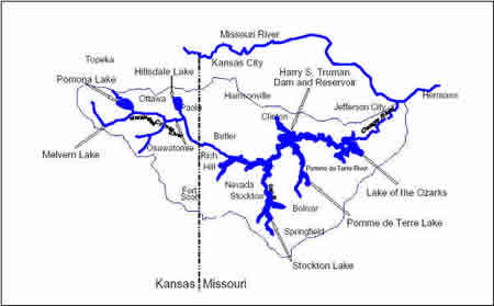
Figure 3: The Marais Des Cygnes-Osage River Basin
Circles of Influence
Circles A and B in the Marais des Cygnes—Osage included the Corps’ Kansas City District, the Kansas Water Office and the Missouri Department of Natural Resources. Each of these entities developed a portion of the shared vision model. Circle C included Kansas City Power and Light, Union Electric, Kansas Department of Wildlife and Parks, Missouri Department of Conservation, economic development commissions and water district managers within the basin.
Planning Objectives for the Marais Des Cygnes—Osage River Basin DPS
-
Increase the reliability of municipal and industrial water service in the Marais des Cygnes—Osage River basin
-
Increase the reliability of recreation opportunities during drought at the six Federal reservoirs and one non-Federal reservoir in the Marais des Cygnes—Osage River Basin
-
Increase the reliability of hydropower generation during drought at the two Federal and one non-Federal reservoirs in the Marais des Cygnes—Osage River basin
-
Increase the dependability of agricultural production during drought in the Marais des Cygnes—Osage River basin
Changes as a result of this DPS
This DPS was suspended during the summer of 1993 because the entire region became involved in efforts to minimize and monitor the flooding damage on the Missouri River and its tributaries.
This DPS is expected to resume in March 1994. At the time of this writing, participants from both states reported that the DPS process had helped improve understanding and cooperation between the states and the Corps, but there has been no determination of alternative plans.