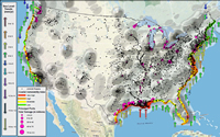
Observed sea-level trends (NOAA), Coastal Vulnerability Index (USGS), USACE Projects, and Port Tonnage on map of Population Density (Census). This map represents collaborative efforts with USGS and NOAA around understanding sea-level change.

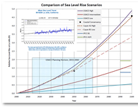
Comparison of Sea-Level Rise Scenarios
ALEXANDRIA, VIRGINIA - December 20, 2011. The U.S. Army Corps of Engineers has released updated guidance to Engineer Circular (EC) 1165-2-211 (2009) “Incorporating Sea-Level Change Considerations in Civil Works Programs.” The new guidance, released in November 2011, is EC 1165-2-212 "Sea-Level Change Considerations for Civil Works Programs."
USACE has a large coastal program that supports inland and maritime transportation, hurricane and coastal risk reduction, and ecosystem restoration. USACE is very interested in what the future holds for coastal areas. Interagency Performance Evaluation (IPET) findings after Hurricane Katrina led USACE to update and expand policies and guidance to incorporate new and changing conditions in project planning and engineering.
The 2009 scenario-based sea-level change guidance was developed with the aid of other agency experts from the National Oceanic and Atmospheric Administration (NOAA) and U.S. Geological Survey (USGS) guidance. It expanded 1986 planning guidance on sea-level change to the whole project life cycle (except regulatory).The guidance series has a two-year lifespan, leading to the new 2011 release. This 2011 update includes:
- additional references and discussion reflecting recent advances and understanding of sea-level change since 2008-2009, including a statement that a credible upper bound for 21st century sea-level rise would not exceed 2 meters. This statement is based upon recent peer-reviewed articles by several authors using different methods but arriving at similar conclusions.
- update to the start date of sea-level rise projection curves to conform with the current NOAA National Tidal Datum Epoch consistent with our datum guidance.
- an additional figure quantifying the expected sea-level change trend error as a function of tidal data record length, to reinforce the need for longer records.
- update to the Appendix C flowchart to address comments from the field about risk assessment.
Learn More